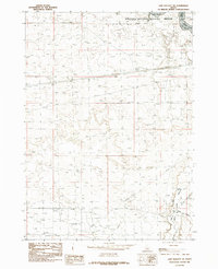
1984 Map of Lake Walcott SE
USGS Topo · Published 1984About this map
The Minidoka National Wildlife Refuge dominates the northern reaches of this mid-1980s landscape, protecting the marshlands and open water where the Snake River pools into Lake Walcott. This area serves as a critical riparian corridor in the high desert, evidenced by the confluence of the Raft River as it winds through the River Valley from the south. The terrain is marked by a network of drainage ditches and a prominent Pipeline, signaling the managed water and energy infrastructure vital to this region of southern Idaho.
Find a feature on this map
9 named features on this map. Tap any name to fly to it.
Don’t see what you’re looking for? This feature index may not catch every label — zoom into the map to look around manually.
Map Details
Editions of this 1984 Lake Walcott SE Map
This is the sole edition of this map. No revisions or reprints were ever made.
Other maps of this area

1954 · Pocatello
USGS Topo · 1:250,000

1958 · Pocatello
USGS Topo · 1:250,000

1958 · Sublett
USGS Topo · 1:62,500

1959 · Lake Walcott
USGS Topo · 1:62,500

1959 · Yale
USGS Topo · 1:62,500

1968 · Malta NE
USGS Topo · 1:24,000

1968 · Idahome
USGS Topo · 1:24,000
1984 · Gifford Spring
USGS Topo · 1:24,000

1984 · North Chapin Mountain
USGS Topo · 1:24,000
1984 · Lake Walcott West
USGS Topo · 1:24,000