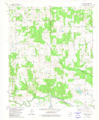
1980 Map of Lake West
USGS Topo · Published 1981About this map
The Blue River and Red River define the southern edge of this Oklahoma-Texas border region, where the floodplain transitions into the wooded creek basins of Bryan County. The small settlement of Lake West sits near the riverbanks, anchored by a network of drainage systems including Whitegrass Creek, Slash Creek, and Frazier Creek. These waterways dictate the local geography, winding through lands once divided among the townships of Bennington and Hunter.
Find a feature on this map
19 named features on this map. Tap any name to fly to it.
Don’t see what you’re looking for? This feature index may not catch every label — zoom into the map to look around manually.
Map Details
Editions of this 1980 Lake West Map
This is the sole edition of this map. No revisions or reprints were ever made.
Other maps of this area

1899 · Atoka
USGS Topo · 1:125,000

1900 · Atoka
USGS Topo · 1:125,000

1901 · Antlers
USGS Topo · 1:125,000

1903 · Paris
USGS Topo · 1:125,000

1912 · Antlers
USGS Topo · 1:125,000

1925 · Antlers
USGS Topo · 1:125,000

1948 · Direct
USGS Topo · 1:62,500

1949 · Direct
USGS Topo · 1:62,500

1950 · Mcalester
USGS Topo · 1:250,000

1953 · Texarkana
USGS Topo · 1:250,000