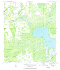
1945 Map of Lake Wimico
USGS Topo · Published 1960About this map
The expanse of Lake Wimico dominates this coastal Florida landscape as it appeared in the mid-1940s, situated along the county line between Gulf and Franklin counties. The region's economy and infrastructure are clearly defined by the transition from traditional water routes to industrial timber and rail networks. The Intracoastal Waterway cuts through the upper portion of the map, including the Clay Cut, while the Apalachicola Northern railroad skirts the western and southern edges.
Find a feature on this map
14 named features on this map. Tap any name to fly to it.
Don’t see what you’re looking for? This feature index may not catch every label — zoom into the map to look around manually.
Map Details
Editions of this 1945 Lake Wimico Map
5 editions found
Other maps of this area

1943 · Port St. Joe
USGS Topo · 1:31,680

1943 · Cape San Blas
USGS Topo · 1:31,680

1943 · West Pass
USGS Topo · 1:31,680

1943 · Overstreet
USGS Topo · 1:31,680

1943 · Indian Pass
USGS Topo · 1:24,000

1943 · Jackson River
USGS Topo · 1:24,000

1944 · White City
USGS Topo · 1:24,000

1944 · Forbes Island
USGS Topo · 1:24,000

1945 · Forbes Island
USGS Topo · 1:31,680

1945 · Lake Wimico
USGS Topo · 1:31,680