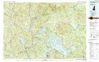
1986 Map of Lake Winnipesaukee
USGS Topo · Published 1988About this map
Lake Winnipesaukee anchors this mid-1980s look at the Lakes Region and the southern edge of the White Mountains, showing a landscape defined by expansive glacial lakes and significant elevation changes. The intricate shoreline of the Big Lake is documented alongside neighboring Squam Lake and Newfound Lake, capturing the area as its identity as a premier recreational destination was well-established. To the north and west, the terrain rises sharply into the White Mountain National Forest and the Sandwich Range, while the Ossipee Mountains form a distinct circular cluster to the east.
Find a feature on this map
58 named features on this map. Tap any name to fly to it.
Don’t see what you’re looking for? This feature index may not catch every label — zoom into the map to look around manually.
Map Details
Editions of this 1986 Lake Winnipesaukee Map
2 editions found
Other maps of this area

1891 · Berwick
USGS Topo · 1:62,500

1891 · Newfield
USGS Topo · 1:62,500

1893 · Berwick
USGS Topo · 1:62,500

1893 · Newfield
USGS Topo · 1:62,500

1894 · North Conway
USGS Topo · 1:62,500

1895 · Crawford Notch
USGS Topo · 1:62,500

1896 · Crawford Notch
USGS Topo · 1:62,500

1896 · North Conway
USGS Topo · 1:62,500

1902 · Sunapee
USGS Topo · 1:62,500

1905 · Sunapee
USGS Topo · 1:62,500