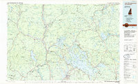
1986 Map of Lake Winnipesaukee
USGS Topo · Published 1986About this map
Lake Winnipesaukee and its complex archipelago dominate this mid-1980s planimetric study, capturing the region's established identity as a premiere recreational and residential landscape. The map details the intricate shoreline and surrounding basins of Squam Lake and Newfound Lake, framed by the formidable Sandwich Range to the north and the circular Ossipee Mountains to the east. The transportation network is a primary focus, showing how State Route 25 and US Highway 3 connect centers like Meredith and Laconia, while the Boston and Maine RR corridors still define the traditional transit paths through Plymouth and Sanbornville.
Find a feature on this map
85 named features on this map. Tap any name to fly to it.
Don’t see what you’re looking for? This feature index may not catch every label — zoom into the map to look around manually.
Map Details
Editions of this 1986 Lake Winnipesaukee Map
2 editions found
Other maps of this area

1891 · Berwick
USGS Topo · 1:62,500

1891 · Newfield
USGS Topo · 1:62,500

1893 · Berwick
USGS Topo · 1:62,500

1893 · Newfield
USGS Topo · 1:62,500

1894 · North Conway
USGS Topo · 1:62,500

1895 · Crawford Notch
USGS Topo · 1:62,500

1896 · Crawford Notch
USGS Topo · 1:62,500

1896 · North Conway
USGS Topo · 1:62,500

1902 · Sunapee
USGS Topo · 1:62,500

1905 · Sunapee
USGS Topo · 1:62,500