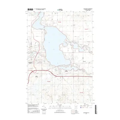
2015 Map of Lake Wissota
USGS Topo · Published 2015About this map
Lake Wissota dominates the central landscape of this Chippewa County region, where the confluence of the Chippewa River, Yellow River, and Paint Creek forms a sprawling reservoir. The eastern edge of Chippewa Falls is visible on the western shore, showing the transition from the industrial and residential city center toward the more recreation-focused shoreline. To the south, the village of Lake Hallie and the smaller settlement of Bateman represent the area's ongoing residential expansion. Local history is anchored by landmarks such as Home Park Cem and Bateman Cem, while the Wissota Airport reflects the mid-century infrastructure supporting the region. The map captures the complex hydrography of the dammed river valley, including smaller water bodies like Cindy Lake and the winding course of Stillson Cr and Frederick Cr as they feed into the primary basin.
Find a feature on this map
118 named features on this map. Tap any name to fly to it.
Don’t see what you’re looking for? This feature index may not catch every label — zoom into the map to look around manually.
Map Details
Editions of this 2015 Lake Wissota Map
This is the sole edition of this map. No revisions or reprints were ever made.
Other maps of this area

1934 · Chippewa Falls
USGS Topo · 1:62,500

1936 · Chippewa Falls
USGS Topo · 1:62,500

1949 · Bloomer
USGS Topo · 1:62,500

1951 · Bloomer
USGS Topo · 1:62,500

1951 · Cornell
USGS Topo · 1:62,500

1952 · Cadott
USGS Topo · 1:62,500

1953 · Eau Claire
USGS Topo · 1:250,000

1953 · Rice Lake
USGS Topo · 1:250,000

1958 · Eau Claire
USGS Topo · 1:250,000

1959 · Rice Lake
USGS Topo · 1:250,000