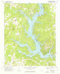
1973 Map of Lake Wylie
USGS Topo · Published 1976About this map
Lake Wylie dominates this 1970s landscape, straddling the border between South Carolina and North Carolina. The map captures the Catawba River valley as it undergoes significant residential and recreational development, seen in the planned streets of Tega Cay and Pine Harbor. Significant infrastructure like the Wylie Dam and the Buster Boyd Bridge facilitate transport and power across the sprawling shoreline. Beyond the water, the terrain is dotted with long-established community landmarks such as Bethel Mission, Liberty Hill Ch, and Union Ch.
Find a feature on this map
56 named features on this map. Tap any name to fly to it.
Don’t see what you’re looking for? This feature index may not catch every label — zoom into the map to look around manually.
Map Details
Editions of this 1973 Lake Wylie Map
This is the sole edition of this map. No revisions or reprints were ever made.
Other maps of this area

1905 · Charlotte
USGS Topo · 1:48,000

1907 · Charlotte
USGS Topo · 1:62,500

1941 · Charlotte
USGS Topo · 1:125,000

1941 · Spartanburg
USGS Topo · 1:250,000

1942 · Charlotte
USGS Topo · 1:125,000

1947 · Clover
USGS Topo · 1:62,500

1948 · Charlotte West
USGS Topo · 1:24,000

1949 · Clover
USGS Topo · 1:62,500

1949 · Charlotte West
USGS Topo · 1:24,000

1949 · Rock Hill
USGS Topo · 1:62,500