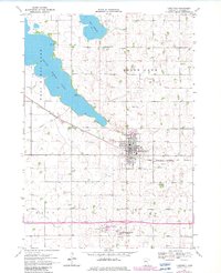
1970 Map of Lakefield
USGS Topo · Published 1982About this map
The town of Lakefield serves as the primary hub in this Jackson County survey, showcasing a landscape defined by prairie agriculture and significant water bodies. To the west, the expansive South Heron Lake and the smaller Lake Flaherty dominate the terrain, while the eastern edge is defined by the larger Heron Lake. The influence of the Chicago Milwaukee St Paul and Pacific railroad is evident, including an abandoned segment that speaks to changing transportation needs. Local history is anchored by sites like Heron Lake Cemetery and Immanuel Cemetery, alongside a Nursing Home and Reder Airfield. The map reveals the critical role of water management in this region, marked by extensive drainage systems like Judicial Ditch No 17 and Judicial Ditch No 3, which transformed the wetlands into productive farmland.
Find a feature on this map
24 named features on this map. Tap any name to fly to it.
Don’t see what you’re looking for? This feature index may not catch every label — zoom into the map to look around manually.
Map Details
Editions of this 1970 Lakefield Map
3 editions found
Other maps of this area

1954 · Fairmont
USGS Topo · 1:250,000

1958 · Fairmont
USGS Topo · 1:250,000

1960 · Okabena
USGS Topo · 1:24,000

1960 · Sioux Valley
USGS Topo · 1:24,000

1970 · Lakefield SW
USGS Topo · 1:24,000

1970 · Lakefield NE
USGS Topo · 1:24,000

1970 · Wilder
USGS Topo · 1:24,000

1970 · Lakefield SE
USGS Topo · 1:24,000

1970 · Lakefield
USGS Topo · 1:24,000

1970 · Windom
USGS Topo · 1:24,000