
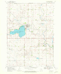
1970 Map of Lakefield SW
USGS Topo · Published 1972About this map
The Little Sioux River winds through this rural borderland between Jackson County, Minnesota, and Dickinson County, Iowa, as it appeared in the early 1970s. This agricultural landscape, divided into the townships of Rost, Hunter, Sioux Valley, and Minneota, is defined by its extensive system of conservation lands. Large tracts such as the Husen State Wildlife Management Area and the Minnesota Slough State Wildlife Management Area dominate the topography, preserving native wetlands and prairie habitat. Scattered throughout the farmsteads are essential community anchors, including Holy Trinity Ch, St Johns Ch, and the Holy Trinity Cem. In the southern portion of the sheet, the waters of Rush Lake and the northern tip of Little Spirit Lake mark the transition across the state line, while a prominent Pipeline cuts a linear path across the western sections, illustrating the modern industrial infrastructure overlaying this traditional prairie environment.
Find a feature on this map
26 named features on this map. Tap any name to fly to it.
Don’t see what you’re looking for? This feature index may not catch every label — zoom into the map to look around manually.
Map Details
Editions of this 1970 Lakefield SW Map
This is the sole edition of this map. No revisions or reprints were ever made.
Other maps of this area

1954 · Fairmont
USGS Topo · 1:250,000

1958 · Fairmont
USGS Topo · 1:250,000

1960 · Okabena
USGS Topo · 1:24,000

1960 · Sioux Valley
USGS Topo · 1:24,000

1970 · Lakefield NE
USGS Topo · 1:24,000

1970 · Okoboji
USGS Topo · 1:24,000

1970 · Lakefield SE
USGS Topo · 1:24,000

1970 · Lakefield
USGS Topo · 1:24,000

1970 · Spirit Lake
USGS Topo · 1:24,000
1970 · Lake Park
USGS Topo · 1:24,000