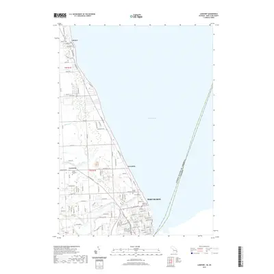
2019 Map of Lakeport
USGS Topo · Published 2019About this map
The western shores of Lake Huron define this 2019 survey of the Michigan coast, where the international boundary between the United States and Canada runs through the open water. Along the shoreline, the community of Lakeport and the sprawling Lakeport State Park anchor the northern reach, while the northern edge of Port Huron occupies the southern corner. The map reveals a high density of specialized burial sites near the city, including the Lakeside Cem Soldiers Lot, Mount Sinai Cem, and Veterans Cem. Inland, the landscape is etched by drainage networks like the Black River Canal, Brace Drain, and Howe Drain, which manage the low-lying terrain between smaller settlements like Gardendale and Keewahdin. This detail provides a clear view of modern residential road networks intersecting older township lines such as t7n r17e.
Find a feature on this map
111 named features on this map. Tap any name to fly to it.
Don’t see what you’re looking for? This feature index may not catch every label — zoom into the map to look around manually.
Map Details
Editions of this 2019 Lakeport Map
This is the sole edition of this map. No revisions or reprints were ever made.
Other maps of this area

1912 · Port Huron
USGS Topo · 1:62,500

1928 · Hicky
USGS Topo · 1:62,500

1929 · Port Huron
USGS Topo · 1:62,500

1939 · Port Huron
USGS Topo · 1:24,000

1939 · Smiths Creek
USGS Topo · 1:24,000
1949 · Port Huron
USGS Topo · 1:24,000
1952 · Smiths Creek
USGS Topo · 1:24,000
1952 · Port Huron
USGS Topo · 1:24,000

1954 · Detroit
USGS Topo · 1:250,000

1954 · Flint
USGS Topo · 1:250,000