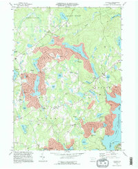
1994 Map of Lakeville
USGS Topo · Published 1996About this map
Lake Wallenpaupack dominates the eastern boundary of this mid-1990s landscape, where the border of Wayne Co and Pike Co meets the water's edge. The region is characterized by a dense concentration of glacial lakes and managed water bodies, from the secluded Lake Lacawac to the residential character surrounding Roamingwood Lake. Small settlements like Lakeville and Arlington serve as focal points for local history, preserving a record of community landmarks such as St Marys Ch and the Little Chapel.
Find a feature on this map
63 named features on this map. Tap any name to fly to it.
Don’t see what you’re looking for? This feature index may not catch every label — zoom into the map to look around manually.
Map Details
Editions of this 1994 Lakeville Map
This is the sole edition of this map. No revisions or reprints were ever made.
Other maps of this area

1892 · Honesdale
USGS Topo · 1:62,500

1920 · Damascus
USGS Topo · 1:62,500

1923 · Damascus
USGS Topo · 1:62,500

1928 · Ariel
USGS Topo · 1:62,500

1932 · Ariel
USGS Topo · 1:62,500

1935 · Hawley
USGS Topo · 1:62,500

1938 · Hawley
USGS Topo · 1:62,500

1943 · Honesdale
USGS Topo · 1:125,000

1944 · Damascus
USGS Topo · 1:62,500

1946 · Honesdale
USGS Topo · 1:24,000