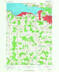
1954 Map of Lakewood
USGS Topo · Published 1967About this map
Chautauqua Lake dominates the northern half of this landscape, its southern shores lined with mid-century resort and residential settlements. The developed waterfront stretches from Lakewood through Celoron and into the industrial heart of Jamestown, where the Chadakoin River drains the lake to the east. The Erie Railroad corridor serves as the primary artery for these communities, following the shoreline before cutting into the urban grid of Jamestown near Persell Sch and Lincoln Jr High Sch.
Find a feature on this map
67 named features on this map. Tap any name to fly to it.
Don’t see what you’re looking for? This feature index may not catch every label — zoom into the map to look around manually.
Map Details
Editions of this 1954 Lakewood Map
3 editions found
Other maps of this area

1904 · Chautaqua
USGS Topo · 1:62,500

1905 · Jamestown
USGS Topo · 1:62,500

1906 · Warren
USGS Topo · 1:62,500

1907 · Warren
USGS Topo · 1:62,500

1908 · Warren
USGS Topo · 1:62,500

1926 · Youngsville
USGS Topo · 1:62,500

1929 · Youngsville
USGS Topo · 1:62,500

1941 · Chautauqua
USGS Topo · 1:62,500

1942 · Jamestown
USGS Topo · 1:62,500

1943 · Youngsville
USGS Topo · 1:62,500