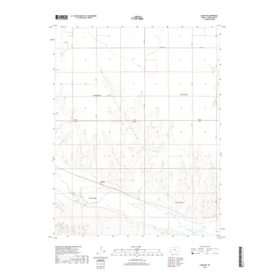
2018 Map of Lakin NW
USGS Topo · Published 2018About this map
Arkansas River flows through the southern portion of this Kearny County landscape, defining the local geography alongside the intermittent path of Sand Cr. In the southwest, the small settlement of Sutton sits near the riverbank, serving as a focal point for the surrounding agricultural sections. The map reveals a highly structured grid of section lines and county routes, including Co Rd 180, Co Rd D, and Co Rd G, which facilitate movement across the high plains of western Kansas. The terrain is marked by gradual elevation changes and drainage patterns that feed toward the river valley, illustrating the characteristic topography of the region as it appeared in the early 21st century.
Find a feature on this map
17 named features on this map. Tap any name to fly to it.
Don’t see what you’re looking for? This feature index may not catch every label — zoom into the map to look around manually.
Map Details
Editions of this 2018 Lakin NW Map
This is the sole edition of this map. No revisions or reprints were ever made.
Other maps of this area

1891 · Larned
USGS Topo · 1:125,000

1900 · Syracuse
USGS Topo · 1:125,000

1900 · Lakin
USGS Topo · 1:125,000

1920 · Syracuse
USGS Topo · 1:125,000

1955 · Dodge City
USGS Topo · 1:250,000

1955 · Scott City
USGS Topo · 1:250,000

1958 · Dodge City
USGS Topo · 1:250,000

1958 · Scott City
USGS Topo · 1:250,000

1959 · Dodge City
USGS Topo · 1:250,000
1966 · Lakin SE
USGS Topo · 1:24,000