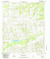
1984 Map of Lamasco
USGS Topo · Published 1985About this map
Lamasco and the surrounding North Texas countryside are defined by a network of creeks and small family burial grounds that trace the settlement history of Fannin County. The landscape is drained by Bois d'Arc Creek and its many tributaries, including Sandy Creek, Pettigrew Branch, and Coffee Mill Creek. These waterways once supported a series of small rural communities such as Hudsonville, Carson, and Pettigrew. A high concentration of family and community cemeteries, including New Hope Cem, Gum Springs Cem, and Cross Cem, provides an invaluable spatial record for genealogists and local historians tracking early residents. The northeastern corner of the map features Coffee Mill Lake, illustrating the post-war transition toward managed water resources in this agricultural region alongside smaller private developments like Lake Quail Haven.
Find a feature on this map
38 named features on this map. Tap any name to fly to it.
Don’t see what you’re looking for? This feature index may not catch every label — zoom into the map to look around manually.
Map Details
Editions of this 1984 Lamasco Map
This is the sole edition of this map. No revisions or reprints were ever made.
Other maps of this area

1903 · Paris
USGS Topo · 1:125,000

1947 · Honey Grove
USGS Topo · 1:62,500

1948 · Direct
USGS Topo · 1:62,500

1949 · Direct
USGS Topo · 1:62,500

1949 · Honey Grove
USGS Topo · 1:62,500

1953 · Texarkana
USGS Topo · 1:250,000

1954 · Sherman
USGS Topo · 1:250,000

1956 · Texarkana
USGS Topo · 1:250,000

1957 · Wade
USGS Topo · 1:62,500

1958 · Bonham
USGS Topo · 1:62,500