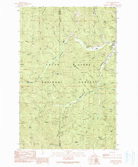
1990 Map of Lamb Peak
USGS Topo · Published 1991About this map
Coeur D'Alene National Forest defines the rugged character of this interior Idaho landscape, where the Kootenai and Shoshone county line follows high ridgelines between drainage basins. The area serves as a significant hub for forest management and back-country access, centered around the Magee Historic Site and the nearby Magee Landing Strip. Transportation through these high valleys relies on a network of historical paths such as the Magee-Bear Trail (Pack) and the Cascade-Magee Road, which connect isolated outposts like the Erickson Ranch. High points including Lamb Peak, Hamilton Mountain, and Leiberg Peak dominate the skyline, while numerous creeks like Big Creek and Tepee Creek carve deep into the terrain. Signs of early 20th-century exploration and resource extraction are evident in scattered landmarks such as the Prospect Adit and Gravel Pit.
Find a feature on this map
57 named features on this map. Tap any name to fly to it.
Don’t see what you’re looking for? This feature index may not catch every label — zoom into the map to look around manually.
Map Details
Editions of this 1990 Lamb Peak Map
This is the sole edition of this map. No revisions or reprints were ever made.
Other maps of this area

1909 · Cataldo
USGS Topo · 1:125,000

1911 · Cataldo
USGS Topo · 1:125,000

1955 · Spokane
USGS Topo · 1:250,000

1957 · Kingston
USGS Topo · 1:62,500

1957 · Kellogg
USGS Topo · 1:62,500

1958 · Spokane
USGS Topo · 1:250,000
1961 · Lakeview
USGS Topo · 1:24,000

1961 · Lakeview
USGS Topo · 1:62,500
1966 · Cathedral Peak
USGS Topo · 1:24,000
1966 · Spyglass Peak
USGS Topo · 1:24,000