1961 Map of Lakeview
USGS Topo · Published 1962About this map
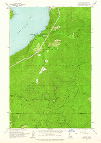
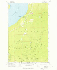
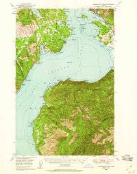
Lakeview sits on the eastern shore of Pend Oreille Lake, serving as a focal point for the silver and lead mining operations that defined this mountain landscape in the early 1960s. The terrain is divided by the Nat Forest Divide, with the northern section falling within the Kaniksu National Forest and the southern portion within the Coeur D'Alene National Forest. This survey captures a dense concentration of hard-rock mining sites tucked into the gulches, including the Silver Leaf Mine, Keep Cool Mine, and Conjecture Mine. High points like Jackknife Peak and Prospect Peak tower over the drainage basins of Gold Creek and the North Fork Coeur D'Alene River. Navigation through this steep backcountry relied heavily on a network of unimproved routes like Bunco Road and various unnamed jeep trails that connected remote claims and lookouts.
Find a feature on this map
56 named features on this map. Tap any name to fly to it.
Don’t see what you’re looking for? This feature index may not catch every label — zoom into the map to look around manually.
Map Details
Editions of this 1961 Lakeview Map
2 editions found
Other maps of this area

1901 · Sandpoint
USGS Topo · 1:125,000

1903 · Rathdrum
USGS Topo · 1:125,000

1909 · Cataldo
USGS Topo · 1:125,000

1911 · Cataldo
USGS Topo · 1:125,000

1911 · Priest Lake
USGS Topo · 1:250,000

1911 · Sandpoint
USGS Topo · 1:125,000

1913 · Priest Lake
USGS Topo · 1:250,000
1949 · Packsaddle Mtn
USGS Topo · 1:62,500

1951 · Packsaddle Mtn
USGS Topo · 1:62,500

1955 · Spokane
USGS Topo · 1:250,000