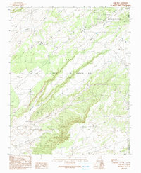
1991 Map of Lamb Well
USGS Topo · Published 1991About this map
Hopi Indian Reservation and Navajo Indian Reservation meet in this high-desert landscape, where the topography is defined by the massive rise of Antelope Mesa. The map documents a sparsely settled region focused on natural water sources and land management, centered around the settlement of Keams near the head of Keams Canyon. This 1991 provisional edition reflects decades of aerial survey work and field checking, capturing a snapshot of the high plateau country of Navajo and Apache counties. Beyond the main settlements, the land is punctuated by isolated resources like Lamb Well and a Water Tank, while the deep channel of Jeddito Wash snakes through the canyon floor. For historians and genealogists, this map preserves the specific placement of these vital desert landmarks within the jurisdictional boundaries of the sovereign tribal nations.
Find a feature on this map
9 named features on this map. Tap any name to fly to it.
Don’t see what you’re looking for? This feature index may not catch every label — zoom into the map to look around manually.
Map Details
Editions of this 1991 Lamb Well Map
This is the sole edition of this map. No revisions or reprints were ever made.
Other maps of this area

1883 · Tusayan
USGS Topo · 1:250,000

1886 · Tusayan
USGS Topo · 1:250,000

1886 · Fort Defiance
USGS Topo · 1:250,000

1892 · Fort Defiance
USGS Topo · 1:250,000

1947 · Flagstaff
USGS Topo · 1:250,000

1954 · Flagstaff
USGS Topo · 1:250,000

1954 · Gallup
USGS Topo · 1:250,000

1958 · Gallup
USGS Topo · 1:250,000

1958 · Flagstaff
USGS Topo · 1:250,000

1959 · Gallup
USGS Topo · 1:250,000