2022 Map of Lamkin
USGS Topo · Published 2022About this map
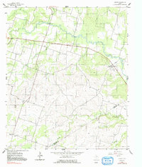
The Leon River winds through the northern half of this landscape, carving a wide valley across a region where the Comanche Co Hamilton Co line marks the southeastern corner. This area is defined by its small agricultural settlements and family-named watercourses, including Mills Cr and Warren Cr. The small community of Siloam serves as a local focal point near the Siloam Cem, while the hamlet of Lamkin sits further east along the river bend. The terrain rises significantly toward the southwest, culminating at the distinctive height of Slick Hill. Genealogists and local historians will find value in the precise location of the rural Energy Cem, situated near the southern boundary. The network of county roads and farm-to-market routes like FM 1702 and FM 2486 reveals a long-standing pattern of ranching and farming connectivity that persists into the modern era.
Find a feature on this map
41 named features on this map. Tap any name to fly to it.
Don’t see what you’re looking for? This feature index may not catch every label — zoom into the map to look around manually.
Map Details
Editions of this 2022 Lamkin Map
This is the sole edition of this map. No revisions or reprints were ever made.