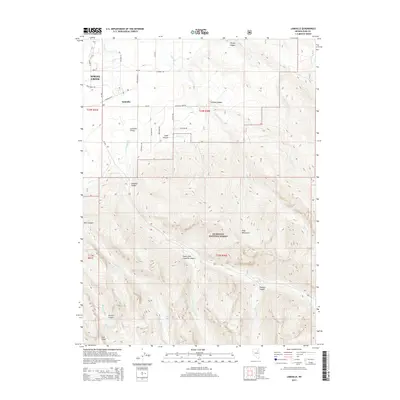
2014 Map of Lamoille
USGS Topo · Published 2014About this map
The settlement of Lamoille sits at the foot of the Ruby Mountains, where the agricultural lands of Lamoille Valley meet the high-elevation wilderness of the Humboldt National Forest. This 2014 survey captures a landscape of extreme verticality, dominated by deep glacial carving in Lamoille Canyon and Thomas Canyon. The map reveals the intricate water network essential to the region, showing Lamoille Creek and its many tributaries like Talbot Creek and Thorpe Creek descending from the peaks. To the southwest, the residential expansion of Spring Creek begins to appear, contrasting with the remote alpine environments of Lee Peak, Seitz Lake, and Griswold Lake. Family-named roads like Sustacha Drive and Dysart Drive provide specific geographic markers for genealogists tracing local land use and development patterns in this corner of Elko County.
Find a feature on this map
47 named features on this map. Tap any name to fly to it.
Don’t see what you’re looking for? This feature index may not catch every label — zoom into the map to look around manually.
Map Details
Editions of this 2014 Lamoille Map
This is the sole edition of this map. No revisions or reprints were ever made.
Other maps of this area

1935 · Halleck
USGS Topo · 1:125,000

1955 · Elko
USGS Topo · 1:250,000

1958 · Elko
USGS Topo · 1:250,000

1962 · Elko
USGS Topo · 1:250,000

1962 · Boyd Reservoir
USGS Topo · 1:24,000

1962 · Lee
USGS Topo · 1:62,500

1962 · Lamoille
USGS Topo · 1:62,500

1965 · Elko
USGS Topo · 1:250,000
1970 · Soldier Peak
USGS Topo · 1:24,000
1971 · Halleck SW
USGS Topo · 1:24,000