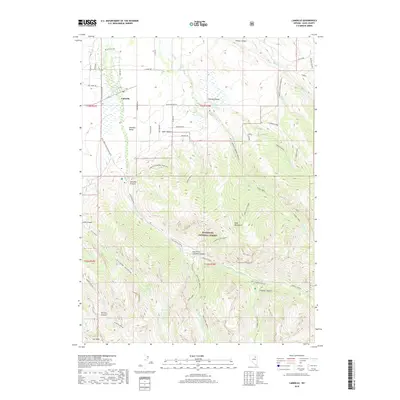
2018 Map of Lamoille
USGS Topo · Published 2018About this map
Lamoille sits at the gateway to the massive glacial carvings of the Ruby Mountains, serving as a central point for the ranching and recreation of the Lamoille Valley. This area is defined by its deep drainages and high alpine basins, where Lamoille Canyon and South Fork Lamoille Canyon cut through the Humboldt National Forest. Infrastructure supporting the local community and seasonal visitors is evident through landmarks like the Lions Camp and the Power House, while the network of ranch roads such as Blume Ranch Rd and Hog Tommy Rd delineate the agricultural floor of the valley. High-altitude features including Seitz Lake, Griswold Lake, and the prominent Lee Peak mark the transition into the high wilderness. The map details a complex system of trails and access points, including the Lamoille-Gardner Creek TH and the Lamoille to Talbot route, which connect the valley floor to the remote canyons and basins above.
Find a feature on this map
58 named features on this map. Tap any name to fly to it.
Don’t see what you’re looking for? This feature index may not catch every label — zoom into the map to look around manually.
Map Details
Editions of this 2018 Lamoille Map
This is the sole edition of this map. No revisions or reprints were ever made.
Other maps of this area

1935 · Halleck
USGS Topo · 1:125,000

1955 · Elko
USGS Topo · 1:250,000

1958 · Elko
USGS Topo · 1:250,000

1962 · Elko
USGS Topo · 1:250,000

1962 · Boyd Reservoir
USGS Topo · 1:24,000

1962 · Lee
USGS Topo · 1:62,500

1962 · Lamoille
USGS Topo · 1:62,500

1965 · Elko
USGS Topo · 1:250,000
1970 · Soldier Peak
USGS Topo · 1:24,000
1971 · Halleck SW
USGS Topo · 1:24,000