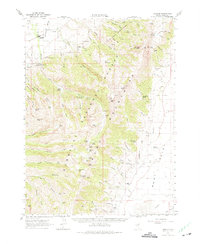
1962 Map of Lamoille
USGS Topo · Published 1975About this map
Lamoille and the eastern slopes of the Ruby Mountains are captured here during the early 1960s, showing a landscape defined by ranching, forestry, and high-altitude water resources. The settlement of Lamoille sits at the mouth of the canyon, supported by a local Powerhouse and Gaging Station, while higher elevations are marked by the presence of Humboldt National Forest facilities like Thomas Canyon Forest Camp and the Terrace Guard Sta.
Find a feature on this map
91 named features on this map. Tap any name to fly to it.
Don’t see what you’re looking for? This feature index may not catch every label — zoom into the map to look around manually.
Map Details
Editions of this 1962 Lamoille Map
2 editions found
Other maps of this area

1934 · Jiggs
USGS Topo · 1:125,000

1935 · Halleck
USGS Topo · 1:125,000

1937 · Jiggs
USGS Topo · 1:125,000

1955 · Elko
USGS Topo · 1:250,000

1958 · Elko
USGS Topo · 1:250,000

1959 · Jiggs
USGS Topo · 1:62,500

1962 · Elko
USGS Topo · 1:250,000

1962 · Boyd Reservoir
USGS Topo · 1:24,000

1962 · Lee
USGS Topo · 1:62,500

1962 · Lamoille
USGS Topo · 1:62,500