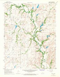
1967 Map of Lamont
USGS Topo · Published 1968About this map
Verdigris River meanders through the heart of this Greenwood County landscape, carving a fertile valley through the distinct townships of Madison, Shell Rock, and Janesville. The map captures a period of transition in local transportation, dominated by the long diagonal sweep of the Atchison Topeka and Santa Fe Railroad Grade and an Old Railroad Grade that speaks to the shifting rail economy of the mid-20th century.
Find a feature on this map
20 named features on this map. Tap any name to fly to it.
Don’t see what you’re looking for? This feature index may not catch every label — zoom into the map to look around manually.
Map Details
Editions of this 1967 Lamont Map
This is the sole edition of this map. No revisions or reprints were ever made.
Other maps of this area

1885 · Burlington
USGS Topo · 1:125,000

1885 · Eureka
USGS Topo · 1:125,000

1886 · Fredonia
USGS Topo · 1:125,000

1888 · Emporia
USGS Topo · 1:125,000

1888 · Eureka
USGS Topo · 1:125,000

1894 · Emporia
USGS Topo · 1:125,000

1894 · Fredonia
USGS Topo · 1:125,000

1894 · Burlington
USGS Topo · 1:125,000

1894 · Eureka
USGS Topo · 1:125,000

1947 · Lawrence
USGS Topo · 1:250,000