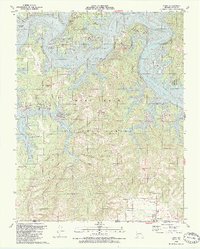
1989 Map of Lampe
USGS Topo · Published 1989About this map
Table Rock Lake winds through the northern half of this late-twentieth-century landscape, framing the Ozark terrain of Stone County. The intricate shoreline of the White River impoundment is marked by steep bluffs like Philibert Bluff and Whiterock Bluff, alongside numerous public access points including the Joe Bald Public Use Area and Baxter Public Use Area. The map illustrates a shift toward recreation and conservation, with much of the central and southern portions protected within the Mark Twain National Forest.
Find a feature on this map
69 named features on this map. Tap any name to fly to it.
Don’t see what you’re looking for? This feature index may not catch every label — zoom into the map to look around manually.
Map Details
Editions of this 1989 Lampe Map
2 editions found
Other maps of this area

1900 · Eureka Springs
USGS Topo · 1:125,000

1901 · Eureka Springs
USGS Topo · 1:125,000

1904 · Harrison
USGS Topo · 1:125,000

1905 · Harrison
USGS Topo · 1:125,000

1907 · Forsyth
USGS Topo · 1:125,000

1927 · Shell Knob
USGS Topo · 1:62,500

1945 · Harrison
USGS Topo · 1:250,000

1949 · Harrison
USGS Topo · 1:250,000

1950 · Shell Knob
USGS Topo · 1:62,500

1950 · Garber
USGS Topo · 1:24,000