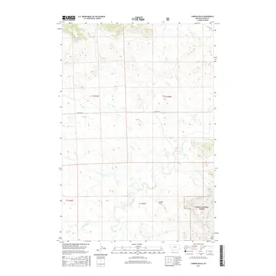
2017 Map of Lampkin Gulch
USGS Topo · Published 2017About this map
Custer National Forest anchors the southeast corner of this landscape, where the rising terrain of the Long Pines meets several distinct water sources. Significant for local land use and stock management, these sources include Arpan Spring, Veece Spring, and Last Chance Spring. The drainage network is particularly dense in this area of Carter County, with Boxelder Creek and Harmon Cr carving paths through the central sections. Historically, the area is defined by its rural connectivity, shown by Mill Iron Rd and Prairiedale Rd, which traverse the open country. The eponymous Lampkin Gulch sits at the heart of this township-and-range grid, providing a central reference point for researchers looking at early twenty-first-century Montana land management and topography.
Find a feature on this map
17 named features on this map. Tap any name to fly to it.
Don’t see what you’re looking for? This feature index may not catch every label — zoom into the map to look around manually.
Map Details
Editions of this 2017 Lampkin Gulch Map
This is the sole edition of this map. No revisions or reprints were ever made.
Other maps of this area

1954 · Ekalaka
USGS Topo · 1:250,000

1956 · Ekalaka
USGS Topo · 1:250,000

1958 · Ekalaka
USGS Topo · 1:250,000

1965 · Ekalaka
USGS Topo · 1:250,000

1980 · Taylor Hills
USGS Topo · 1:24,000

1980 · Belltower
USGS Topo · 1:24,000
1980 · Rustler Divide
USGS Topo · 1:24,000

1980 · Camp Needmore
USGS Topo · 1:24,000

1980 · Dutchmans Hill
USGS Topo · 1:24,000
1980 · Lampkin Gulch
USGS Topo · 1:24,000