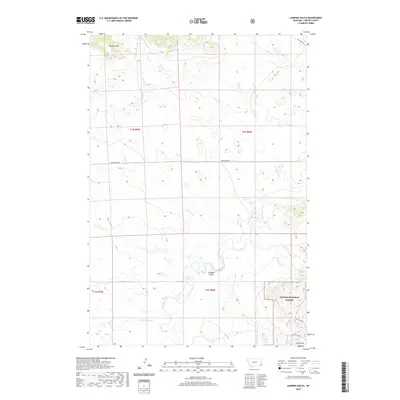
2020 Map of Lampkin Gulch
USGS Topo · Published 2020About this map
The Custer National Forest and Long Pines region of Carter County defines this portion of southeast Montana, where the terrain transitions from open creek valleys into the wooded uplands of the Ekalaka Hills. The landscape is dominated by the drainage systems of Boxelder Creek and its many tributaries, including Corral Cr, Harmon Cr, and Little Ramme Cr. High-country water sources are particularly prominent on this survey, which identifies several named springs such as Arpan Spring, Neece Spring, Iron Spring, and the evocatively named Last Chance Spring. Human infrastructure is sparse in this section of the state, primarily consisting of remote ranch access via Mill Iron Rd and Prairiedale Rd, reflecting the long-standing land-use patterns of the Northern Plains.
Find a feature on this map
19 named features on this map. Tap any name to fly to it.
Don’t see what you’re looking for? This feature index may not catch every label — zoom into the map to look around manually.
Map Details
Editions of this 2020 Lampkin Gulch Map
This is the sole edition of this map. No revisions or reprints were ever made.
Other maps of this area

1954 · Ekalaka
USGS Topo · 1:250,000

1956 · Ekalaka
USGS Topo · 1:250,000

1958 · Ekalaka
USGS Topo · 1:250,000

1965 · Ekalaka
USGS Topo · 1:250,000

1980 · Taylor Hills
USGS Topo · 1:24,000

1980 · Belltower
USGS Topo · 1:24,000
1980 · Rustler Divide
USGS Topo · 1:24,000

1980 · Camp Needmore
USGS Topo · 1:24,000

1980 · Dutchmans Hill
USGS Topo · 1:24,000
1980 · Lampkin Gulch
USGS Topo · 1:24,000