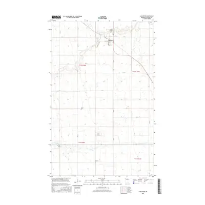
2016 Map of Lancaster
USGS Topo · Published 2016About this map
Lancaster serves as the central hub of this northwestern Minnesota landscape, where the town grid meets the meandering paths of the N Br Two Rivers and the Middle Br Two Rivers. The map reveals a high concentration of sites important for local genealogy and heritage, including Saron Cem, Union Liberty Cem, and Bethlehem Cem. On the northern edge of the village, Riverview Memorial Gardens borders the local road network of Central Ave and Iowa Ave. The surrounding terrain is defined by the Section-Line roads typical of the Red River Valley region, with routes like Co Rd 4 and Co Rd 17 cutting across the agricultural plains to connect outlying farms and community centers.
Find a feature on this map
25 named features on this map. Tap any name to fly to it.
Don’t see what you’re looking for? This feature index may not catch every label — zoom into the map to look around manually.
Map Details
Editions of this 2016 Lancaster Map
This is the sole edition of this map. No revisions or reprints were ever made.
Other maps of this area

1918 · Hemmington
USGS Topo · 1:62,500

1939 · Kennedy
USGS Topo · 1:62,500

1941 · Kennedy
USGS Topo · 1:62,500

1941 · Hallock
USGS Topo · 1:62,500

1952 · Thief River Falls
USGS Topo · 1:250,000

1956 · Thief River Falls
USGS Topo · 1:250,000

1956 · Karlstad
USGS Topo · 1:62,500

1957 · Thief River Falls
USGS Topo · 1:250,000

1966 · Skull Lake
USGS Topo · 1:24,000
1966 · Skull Lake SW
USGS Topo · 1:24,000