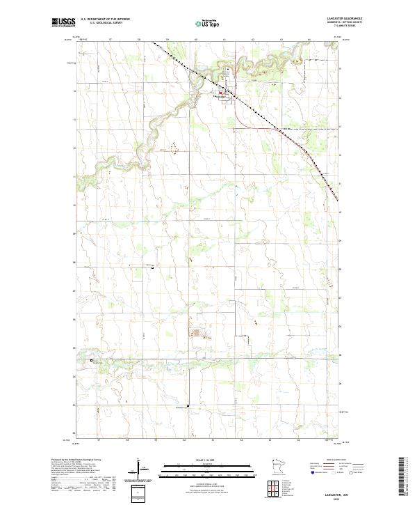
2022 Map of Lancaster
USGS Topo · Published 2022About this map
The city of Lancaster sits at the junction of several county routes in Kittson County, serving as the primary hub for this agricultural landscape near the Canadian border. The terrain is defined by the winding paths of the N Br Two Rivers and the Middle Br Two Rivers, which carve across the prairie. For genealogists and local historians, this survey identifies several distinct burial sites dispersed through the township, including Riverview Memorial Gardens on the northern edge of the settlement, and more remote rural locations such as Saron Cem, Union Liberty Cem, and Bethlehem Cem. The map reveals a highly structured grid of section lines and gravel roads, including Co RD 6 and Co RD 17, which facilitate the movement of goods in this remote corner of Minnesota.
Find a feature on this map
18 named features on this map. Tap any name to fly to it.
Don’t see what you’re looking for? This feature index may not catch every label — zoom into the map to look around manually.
Map Details
Editions of this 2022 Lancaster Map
This is the sole edition of this map. No revisions or reprints were ever made.
Other maps of this area

1918 · Hemmington
USGS Topo · 1:62,500

1939 · Kennedy
USGS Topo · 1:62,500

1941 · Kennedy
USGS Topo · 1:62,500

1941 · Hallock
USGS Topo · 1:62,500

1952 · Thief River Falls
USGS Topo · 1:250,000

1956 · Thief River Falls
USGS Topo · 1:250,000

1956 · Karlstad
USGS Topo · 1:62,500

1957 · Thief River Falls
USGS Topo · 1:250,000

1966 · Skull Lake
USGS Topo · 1:24,000
1966 · Skull Lake SW
USGS Topo · 1:24,000