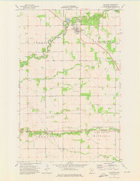
1974 Map of Lancaster
USGS Topo · Published 1976About this map
Lancaster serves as the central hub of this Kittson County landscape, situated where the Soo Line railroad cuts across the agricultural plains of northwest Minnesota. The town is flanked by essential infrastructure of the mid-1970s, including the Lancaster Municipal Airport and Sewage Disposal Ponds, while the surrounding townships of Granville, Poppleton, Thompson, and Hazelton reveal a meticulously planned grid of rural drainage and transport.
Find a feature on this map
19 named features on this map. Tap any name to fly to it.
Don’t see what you’re looking for? This feature index may not catch every label — zoom into the map to look around manually.
Map Details
Editions of this 1974 Lancaster Map
This is the sole edition of this map. No revisions or reprints were ever made.
Other maps of this area

1918 · Hemmington
USGS Topo · 1:62,500

1939 · Kennedy
USGS Topo · 1:62,500

1941 · Kennedy
USGS Topo · 1:62,500

1941 · Hallock
USGS Topo · 1:62,500

1952 · Thief River Falls
USGS Topo · 1:250,000

1956 · Thief River Falls
USGS Topo · 1:250,000

1956 · Karlstad
USGS Topo · 1:62,500

1957 · Thief River Falls
USGS Topo · 1:250,000

1966 · Skull Lake
USGS Topo · 1:24,000
1966 · Skull Lake SW
USGS Topo · 1:24,000