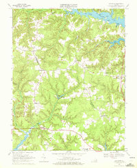
1968 Map of Lancaster
USGS Topo · Published 1972About this map
The Northumberland Co Lancaster Co boundary divides this landscape of winding creeks and rural crossroads in the late 1960s. The county seat at Lancaster serves as a southern anchor, while the village of Wicomico Church centers the eastern portion of the sheet. The terrain is defined by the tidal reaches of the Great Wicomico River and the Corrotoman River, where numerous landings like Deep Landing and Coopers Landing hint at the area's long reliance on water transport. Education and faith are central to the community's structure, evidenced by the Brook Vale High Sch and several country churches including Morning Star Ch and Willis Chapel. Interior drainage is managed through systems like Davis Millpond and the marshes of Callahan Swamp, showing a land still deeply shaped by its natural hydrology before modern development intensified.
Find a feature on this map
49 named features on this map. Tap any name to fly to it.
Don’t see what you’re looking for? This feature index may not catch every label — zoom into the map to look around manually.
Map Details
Editions of this 1968 Lancaster Map
3 editions found
Other maps of this area

1916 · Kilmarnock
USGS Topo · 1:48,000

1917 · Heathsville
USGS Topo · 1:48,000

1917 · Urbanna
USGS Topo · 1:62,500

1917 · Morattico
USGS Topo · 1:62,500

1917 · Kilmarnock
USGS Topo · 1:62,500

1918 · Morattico
USGS Topo · 1:62,500

1926 · Morattico
USGS Topo · 1:62,500

1942 · Kilmarnock
USGS Topo · 1:62,500

1943 · Richmond
USGS Topo · 1:250,000
1944 · Sunnybank
USGS Topo · 1:31,680