
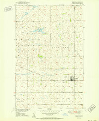
1950 Map of Landa SW
USGS Topo · Published 1950About this map
The Lower Souris National Wildlife Refuge dominates the landscape of Bottineau County in this 1950 survey, following the winding course of the Lower Souris River. This area of North Dakota exhibits a highly organized section-line grid system, typical of the Missouri River Basin development era. The map records the rural social structure of the mid-century, specifically marking local centers of education such as School No 2, School No 3, and School No 4. The terrain is divided into distinct civil townships including Sergius, Eidsvold, Starbuck, Kane, and Brandon, each reflecting the settlement patterns of the Northern Plains. While the waterway and its associated marshlands provide a natural corridor, the presence of a Gravel Pit near the river suggests the localized extraction industries that supported regional infrastructure and road building during this period.
Find a feature on this map
12 named features on this map. Tap any name to fly to it.
Don’t see what you’re looking for? This feature index may not catch every label — zoom into the map to look around manually.
Map Details
Editions of this 1950 Landa SW Map
This is the sole edition of this map. No revisions or reprints were ever made.
Other maps of this area

1949 · Eckman
USGS Topo · 1:24,000

1949 · Landa
USGS Topo · 1:24,000

1949 · Landa SW
USGS Topo · 1:24,000

1950 · Newburg
USGS Topo · 1:24,000

1950 · Deep
USGS Topo · 1:24,000

1950 · Landa
USGS Topo · 1:24,000

1951 · Westhope SE
USGS Topo · 1:24,000
1951 · Westhope
USGS Topo · 1:24,000

1954 · Landa SE
USGS Topo · 1:24,000

1954 · Roth
USGS Topo · 1:24,000