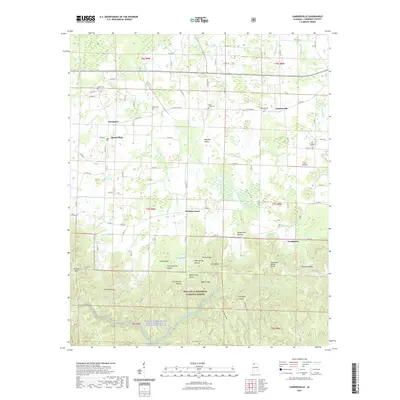
2021 Map of Landersville
USGS Topo · Published 2021About this map
Landersville and the community of Mount Hope anchor the northern reaches of this Lawrence County landscape, where the transition from agricultural valley to deep woodland is marked by the Tennessee Valley Divide. The southern half of the sheet is dominated by the dense, dissected topography of the William B. Bankhead National Forest, a region defined by complex drainage systems and steep landforms like Flannagin Canyon and Goat Bluff. The Sipsey Fork of the West Fork Wild and Scenic River winds through the southwestern corner, illustrating the protected wilderness character of the area. Genealogists will find a variety of family burial sites preserved across the map, including the Old Prospect Cem, Smith Cem, and Wear Cem. The road network connects small crossroads such as Hickory Grove and Needmore to larger arteries like Old AL Hwy 24.
Find a feature on this map
108 named features on this map. Tap any name to fly to it.
Don’t see what you’re looking for? This feature index may not catch every label — zoom into the map to look around manually.
Map Details
Editions of this 2021 Landersville Map
This is the sole edition of this map. No revisions or reprints were ever made.
Other maps of this area

1924 · Tuscumbia
USGS Topo · 1:48,000

1926 · Tuscumbia
USGS Topo · 1:62,500

1935 · Moulton
USGS Topo · 1:24,000

1936 · Newburg
USGS Topo · 1:24,000

1936 · Kinlock Spring
USGS Topo · 1:24,000

1936 · Moulton
USGS Topo · 1:48,000

1936 · Masterson
USGS Topo · 1:24,000

1936 · Hatton
USGS Topo · 1:24,000

1936 · Landersville
USGS Topo · 1:24,000
1936 · Old Bethel
USGS Topo · 1:24,000