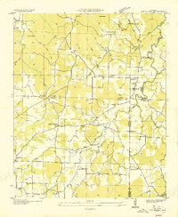
1936 Map of Old Bethel
USGS Topo · Published 1936About this map
Old Bethel serves as the focal point for this 1930s landscape where the borders of Colbert, Franklin, and Lawrence counties converge. The Tennessee Valley Authority, under chairman Arthur E. Morgan, conducted this field examination during a period of significant regional transition, documenting a dense network of small agrarian communities defined by their local institutions. The map reveals an intricate social geography, with numerous rural schools like Rocky Glen Sch and Bruton Sch distributed to serve outlying families.
Find a feature on this map
54 named features on this map. Tap any name to fly to it.
Don’t see what you’re looking for? This feature index may not catch every label — zoom into the map to look around manually.
Map Details
Editions of this 1936 Old Bethel Map
This is the sole edition of this map. No revisions or reprints were ever made.
Other maps of this area

1924 · Tuscumbia
USGS Topo · 1:48,000

1926 · Tuscumbia
USGS Topo · 1:62,500

1936 · Russellville
USGS Topo · 1:24,000

1936 · Newburg
USGS Topo · 1:24,000

1936 · Moulton
USGS Topo · 1:48,000

1936 · Spruce Pine
USGS Topo · 1:24,000

1936 · Town Creek
USGS Topo · 1:24,000
1936 · Leighton
USGS Topo · 1:24,000
1936 · Tuscumbia
USGS Topo · 1:24,000

1936 · Hatton
USGS Topo · 1:24,000