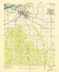
1936 Map of Tuscumbia
USGS Topo · Published 1936About this map
Industrial and agricultural history converge in this 1936 study as the Tennessee Valley Authority transforms the Tennessee River landscape. The map centers on the established urban grid of Tuscumbia and nearby Sheffield, while highlighting the massive federal footprint of the Nitrate Plant No 1 and the U S Nitrate Plant No 1 Townsite. Beyond the industrial centers, the map documents a dense network of rural life, featuring smaller settlements like Spring Valley Station and Valdosta, alongside the County Farm. To the south, the terrain rises toward Underwood Mountain, marked by numerous family and community landmarks such as Mitchell Cem and Underwood Cem. The presence of the Proposed Pickwick Landing Reservoir indicates a region on the cusp of significant hydrological change, as the Tennessee Valley Authority Transmission Line begins to lace across the quadrangle.
Find a feature on this map
59 named features on this map. Tap any name to fly to it.
Don’t see what you’re looking for? This feature index may not catch every label — zoom into the map to look around manually.
Map Details
Editions of this 1936 Tuscumbia Map
This is the sole edition of this map. No revisions or reprints were ever made.
Other maps of this area

1914 · Muscle Shoals
USGS Topo · 1:48,000

1916 · Muscle Shoals
USGS Topo · 1:62,500

1924 · Tuscumbia
USGS Topo · 1:48,000

1924 · Gravelly Springs
USGS Topo · 1:48,000

1925 · Barton
USGS Topo · 1:62,500

1926 · Tuscumbia
USGS Topo · 1:62,500

1926 · Barton
USGS Topo · 1:48,000

1926 · Gravelly Springs
USGS Topo · 1:62,500

1929 · Barton
USGS Topo · 1:62,500

1936 · Russellville
USGS Topo · 1:24,000