
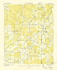
1936 Map of Landersville
USGS Topo · Published 1936About this map
Moulton Valley defines the northern half of this 1936 survey, where the settlement of Landersville sits along State Highway No 24. The landscape is dotted with a high density of rural institutions, including Frog Pond Sch, Jamison Sch, and Town Creek Ch, reflecting a well-established agrarian community before modern consolidation. To the south, the terrain rises sharply toward Sand Mountain, where the National Forest Boundary marks the edge of the Black Warrior National Forest. The Tennessee Divide cuts through this southern upland, separating the Town Creek drainage from the headwaters of Maddox Creek. This transition from the open valley floor to the wooded ridges of Stinson Gap and McClung Gap illustrates the sharp geographic divide between the cultivated lowlands and the protected timberlands of the plateau.
Find a feature on this map
44 named features on this map. Tap any name to fly to it.
Don’t see what you’re looking for? This feature index may not catch every label — zoom into the map to look around manually.
Map Details
Editions of this 1936 Landersville Map
This is the sole edition of this map. No revisions or reprints were ever made.
Other maps of this area

1924 · Tuscumbia
USGS Topo · 1:48,000

1926 · Tuscumbia
USGS Topo · 1:62,500

1935 · Moulton
USGS Topo · 1:24,000

1936 · Newburg
USGS Topo · 1:24,000

1936 · Kinlock Spring
USGS Topo · 1:24,000

1936 · Moulton
USGS Topo · 1:48,000

1936 · Masterson
USGS Topo · 1:24,000

1936 · Hatton
USGS Topo · 1:24,000
1936 · Old Bethel
USGS Topo · 1:24,000

1940 · Mt Hope
USGS Topo · 1:62,500