
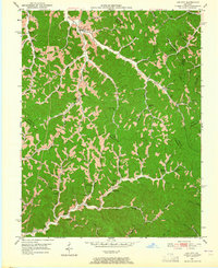
1951 Map of Landsaw
USGS Topo · Published 1953About this map
Bethany Orphanage and its associated Bethany Ch stand as a central social landmark in the early 1950s within this deeply dissected landscape. The terrain is characterized by a dense network of winding hollows and branches, where family names are etched into the geography via sites like the Hollon Cem, Puckett Cem, and Murphy Cem. Small rural schools served isolated communities throughout the hills, including the Buchanan Sch and Malaga Sch. The local economy of the time is visible in the emergence of extractive industries, noted by a Strip Mine in the northeast and scattered Gas Wells near the Wolfe and Breathitt County line. Small settlements such as Vancleve and Sewell cling to the banks of the North Fork Kentucky River, which forms the southern boundary of this Appalachian survey.
Find a feature on this map
80 named features on this map. Tap any name to fly to it.
Don’t see what you’re looking for? This feature index may not catch every label — zoom into the map to look around manually.
Map Details
Editions of this 1951 Landsaw Map
This is the sole edition of this map. No revisions or reprints were ever made.
Other maps of this area

1889 · Salyersville
USGS Topo · 1:125,000

1891 · Salyersville
USGS Topo · 1:125,000

1892 · Beattyville
USGS Topo · 1:125,000

1899 · Salyersville
USGS Topo · 1:125,000

1951 · Cannel City
USGS Topo · 1:24,000

1951 · Hazel Green
USGS Topo · 1:24,000

1951 · Pomeroyton
USGS Topo · 1:24,000

1951 · Quicksand
USGS Topo · 1:24,000

1951 · Jackson
USGS Topo · 1:24,000
1951 · Lee City
USGS Topo · 1:24,000