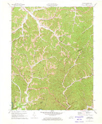
1971 Map of Landsaw
USGS Topo · Published 1973About this map
Bethany and the Childrens Home stand along the winding Holly Creek in this 1970s topographic study of the Kentucky Cumberland Plateau. The landscape is defined by its complex drainage network, where the North Fork Kentucky River cuts through the southwestern corner near Vancleve. Cultural and religious landmarks are densely scattered throughout the hollows, including the Hour of Harvest Ch, Hation Chapel, and the Tacket-Wells Ch near Landsaw. Resource extraction is evident through numerous Gas Wells and Oil Wells distributed across the ridges, alongside a Strip Mine in the northwest. The presence of the Mountain Parkway cutting across the northern reaches indicates a shift toward modern transportation through the traditional settlement patterns of Wolfe County and Breathitt County.
Find a feature on this map
70 named features on this map. Tap any name to fly to it.
Don’t see what you’re looking for? This feature index may not catch every label — zoom into the map to look around manually.
Map Details
Editions of this 1971 Landsaw Map
This is the sole edition of this map. No revisions or reprints were ever made.
Other maps of this area

1889 · Salyersville
USGS Topo · 1:125,000

1891 · Salyersville
USGS Topo · 1:125,000

1892 · Beattyville
USGS Topo · 1:125,000

1899 · Salyersville
USGS Topo · 1:125,000

1951 · Cannel City
USGS Topo · 1:24,000

1951 · Landsaw
USGS Topo · 1:24,000

1951 · Hazel Green
USGS Topo · 1:24,000

1951 · Pomeroyton
USGS Topo · 1:24,000

1951 · Quicksand
USGS Topo · 1:24,000

1951 · Jackson
USGS Topo · 1:24,000