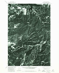
1975 Map of Lane SW
USGS Topo · Published 1977About this map
Mount Coeur d'Alene dominates this orthophoto quadrangle, where the high timbered ridges of the Idaho panhandle meet the northern reaches of Lake Coeur d'Alene. Captured in the mid-1970s through aerial photography, the imagery reveals a landscape of dense forest management and complex topography. The shoreline of Wolf Lodge Bay is visible at the northern edge, showing the intersection of waterway and land. The drainage of Carlin Creek carves through the lower elevations, while Red Horse Mtn stands as a prominent landmark to the east. This specialized survey, produced in cooperation with the Bureau of Indian Affairs and Soil Conservation Service, uses scanned photoimagery to provide a clear view of the road networks and timber harvest patterns that defined the regional economy during this era.
Find a feature on this map
4 named features on this map. Tap any name to fly to it.
Don’t see what you’re looking for? This feature index may not catch every label — zoom into the map to look around manually.
Map Details
Editions of this 1975 Lane SW Map
This is the sole edition of this map. No revisions or reprints were ever made.
Other maps of this area

1903 · Rathdrum
USGS Topo · 1:125,000

1955 · Spokane
USGS Topo · 1:250,000

1957 · St. Maries
USGS Topo · 1:62,500

1957 · Plummer
USGS Topo · 1:62,500

1957 · Coeur D'Alene
USGS Topo · 1:62,500

1957 · Lane
USGS Topo · 1:62,500

1958 · Spokane
USGS Topo · 1:250,000

1975 · Coeur D'Alene SE
USGS Topo · 1:24,000

1975 · Plummer NE
USGS Topo · 1:24,000
1975 · Lane NW
USGS Topo · 1:24,000