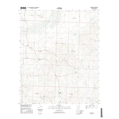
2017 Map of Laneburg
USGS Topo · Published 2017About this map
Laneburg stands as a central settlement in this portion of Nevada County, where rural life is shaped by the numerous creek branches and springs flowing through the landscape. The area is characterized by a network of local roads such as Nevada 291 RD and Co RD 34 that connect small communities and family burial grounds. Notable landmarks include Mount Moriah to the south and the small community of Cale at the southeastern edge. This landscape is historically defined by its water sources, from the larger Terre Rouge Creek in the northwest to the more localized Serepta Spring and Serepta Spring Cem. Genealogists will find significant value in the distribution of several cemeteries, including Westmoreland Cem, Laneburg Cem, and Bluff Springs Cem, which serve as quiet markers of the region's long-established family homesteads and local heritage.
Find a feature on this map
58 named features on this map. Tap any name to fly to it.
Don’t see what you’re looking for? This feature index may not catch every label — zoom into the map to look around manually.
Map Details
Editions of this 2017 Laneburg Map
This is the sole edition of this map. No revisions or reprints were ever made.
Other maps of this area

1901 · Gurdon
USGS Topo · 1:125,000

1953 · El Dorado
USGS Topo · 1:250,000

1957 · El Dorado
USGS Topo · 1:250,000

1958 · El Dorado
USGS Topo · 1:250,000

1960 · El Dorado
USGS Topo · 1:250,000

1970 · Whelen Springs
USGS Topo · 1:24,000

1970 · Prescott East
USGS Topo · 1:24,000
1970 · Prescott West
USGS Topo · 1:24,000
1972 · Gurdon
USGS Topo · 1:62,500
1973 · Bodcaw
USGS Topo · 1:24,000