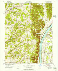
1955 Map of Lanesville
USGS Topo · Published 1956About this map
The Ohio River carves a dramatic boundary through this mid-century landscape, separating the high ridges of Harrison County, Indiana, from the riverfront developments of Kentucky. On the Indiana side, the community of Lanesville serves as a northern anchor, surrounded by family-named landmarks and rural institutions like the St Johns Sch and Lanesville Cem. The terrain is defined by a series of prominent knobs and ridges, including Hickman Hill and Rock House Ridge, which loom over the river valley. Along the western bank, small settlements like Bridgeport and the Locust Point PO highlight a river-oriented economy, while the Kentucky shore near Riverside Gardens and Sylvania shows a different pattern of settlement along the Illinois Central railroad and Cane Run. This survey captures the region just before significant suburban expansion, preserving the locations of numerous country churches such as Antioch Ch and Bethesda Ch.
Find a feature on this map
73 named features on this map. Tap any name to fly to it.
Don’t see what you’re looking for? This feature index may not catch every label — zoom into the map to look around manually.
Map Details
Editions of this 1955 Lanesville Map
This is the sole edition of this map. No revisions or reprints were ever made.
Other maps of this area

1909 · Kosmosdale
USGS Topo · 1:48,000

1912 · Kosmosdale
USGS Topo · 1:62,500

1931 · Corydon
USGS Topo · 1:62,500

1939 · New Albany
USGS Topo · 1:24,000

1939 · Georgetown
USGS Topo · 1:24,000

1946 · New Albany
USGS Topo · 1:24,000

1947 · Georgetown
USGS Topo · 1:24,000

1948 · Corydon East
USGS Topo · 1:24,000

1948 · Laconia
USGS Topo · 1:24,000

1949 · Georgetown
USGS Topo · 1:24,000