
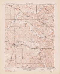
1947 Map of Georgetown
USGS Topo · Published 1947About this map
Georgetown and the surrounding townships of Greenville, Lafayette, and Franklin define this mid-century landscape in Floyd County. The Southern railroad line cuts east-west through the heart of the area, connecting the small stations and hamlets of Duncan and Edwardsville. This survey, conducted just before the Second World War, captures a network of rural roads such as the Old Vincennes Road, Paoli Pike, and Corydon Road, which serve as the primary arteries for local commerce and travel between the knobs and valleys.
Find a feature on this map
37 named features on this map. Tap any name to fly to it.
Don’t see what you’re looking for? This feature index may not catch every label — zoom into the map to look around manually.
Map Details
Editions of this 1947 Georgetown Map
2 editions found
Other maps of this area

1909 · Kosmosdale
USGS Topo · 1:48,000

1912 · Kosmosdale
USGS Topo · 1:62,500

1931 · Corydon
USGS Topo · 1:62,500

1938 · Speed
USGS Topo · 1:24,000

1939 · New Albany
USGS Topo · 1:24,000

1939 · Georgetown
USGS Topo · 1:24,000

1941 · Borden
USGS Topo · 1:24,000

1946 · New Albany
USGS Topo · 1:24,000

1947 · Speed
USGS Topo · 1:24,000

1948 · Corydon East
USGS Topo · 1:24,000