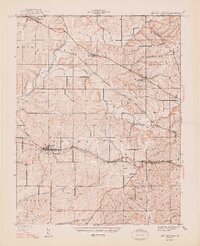
1947 Map of Georgetown
USGS Topo · Published 1947About this map
The Southern railroad corridor and the winding course of Big Indian Creek define the landscape of Floyd County in this pre-war survey. Georgetown serves as a central hub, where the rail line meets local thoroughfares like the Old Corydon Road, facilitating the transport of agricultural goods from the surrounding townships. To the north, the Mt St Francis Seminary stands as a prominent landmark near Galena, while the southern reaches of the map transition into a series of distinct ridges, including Pond Ridge and Skipsey Ridge. This topography reflects the transition from the rolling upland plateaus toward the more deeply dissected terrain near the Ohio River valley. Genealogists will find a wealth of local history in the distribution of family-named cemeteries such as Swartz Cem and Buttontown Cem, which mark early settlement patterns along the Vincennes Road and other historical turnpikes.
Find a feature on this map
45 named features on this map. Tap any name to fly to it.
Don’t see what you’re looking for? This feature index may not catch every label — zoom into the map to look around manually.
Map Details
Editions of this 1947 Georgetown Map
2 editions found
Other maps of this area

1909 · Kosmosdale
USGS Topo · 1:48,000

1912 · Kosmosdale
USGS Topo · 1:62,500

1931 · Corydon
USGS Topo · 1:62,500

1938 · Speed
USGS Topo · 1:24,000

1939 · New Albany
USGS Topo · 1:24,000

1939 · Georgetown
USGS Topo · 1:24,000

1941 · Borden
USGS Topo · 1:24,000

1946 · New Albany
USGS Topo · 1:24,000

1947 · Speed
USGS Topo · 1:24,000

1947 · Georgetown
USGS Topo · 1:24,000