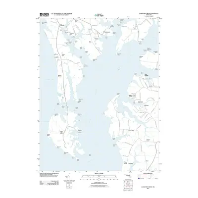
2011 Map of Langford Creek
USGS Topo · Published 2011About this map
Chester River dominates this landscape of the Maryland Eastern Shore, where winding tidal tributaries like Grays Inn Creek and Lankford Creek create a jagged shoreline of points and necks. The map documents a rural waterfront economy transitioning between traditional maritime activities and recreational land use, visible in the proximity of Learys Wharf and Spaniards Landing to modern facilities like the Lankford Bay Marina. Large agricultural holdings and named estates such as Pioneer Point Farms and Bulle Rock Farm occupy the fertile ground between the creeks, while small settlements like New Yarmouth, Crosby, and McKinleyville anchor the inland crossroads. For those tracing local heritage, the map identifies specific landmarks like Gouldtown Cemetery and family-named features such as Crawford's Chance Farm, providing a detailed look at the land-water interface of Queen Anne’s County.
Find a feature on this map
120 named features on this map. Tap any name to fly to it.
Don’t see what you’re looking for? This feature index may not catch every label — zoom into the map to look around manually.
Map Details
Editions of this 2011 Langford Creek Map
This is the sole edition of this map. No revisions or reprints were ever made.
Other maps of this area

1892 · Annapolis
USGS Topo · 1:62,500

1893 · North Point
USGS Topo · 1:62,500

1898 · Choptank
USGS Topo · 1:125,000

1898 · Tolchester
USGS Topo · 1:125,000

1901 · Chestertown
USGS Topo · 1:62,500

1903 · Tolchester
USGS Topo · 1:125,000

1904 · St. Michaels
USGS Topo · 1:62,500

1904 · North Point
USGS Topo · 1:62,500

1904 · Annapolis
USGS Topo · 1:62,500

1908 · Tolchester
USGS Topo · 1:125,000