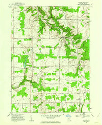
1960 Map of Langford
USGS Topo · Published 1962About this map
Langford serves as a central hub for this rural portion of Erie County, situated at the intersection of Langford Road and Jennings Road. The landscape is characterized by a significant concentration of Gas Wells and Gas Well sites, particularly around the central and southern sections, indicating the region's active energy extraction during the early 1960s. Local history is anchored by St Martin Ch and the nearby Dittman Cem, while the winding course of Eighteenmile Creek and its tributaries, the North Branch and South Branch, carve through the terrain near Clarksburg and New Oregon. To the west, the recreational and geographical focal point of Clear Lake stands out near Marshfield, where Camp Hemlock Ridge occupies the wooded slopes above the water. Small crossroads communities like Whites Corners, Morton Corners, and Wyandale define the historical settlement pattern of the surrounding townships.
Find a feature on this map
56 named features on this map. Tap any name to fly to it.
Don’t see what you’re looking for? This feature index may not catch every label — zoom into the map to look around manually.
Map Details
Editions of this 1960 Langford Map
2 editions found
Other maps of this area

1905 · Eden
USGS Topo · 1:62,500

1907 · Eden
USGS Topo · 1:62,500

1923 · Cattaraugus
USGS Topo · 1:62,500

1924 · Ellicottville
USGS Topo · 1:62,500

1925 · Springville
USGS Topo · 1:62,500

1938 · Cattaraugus
USGS Topo · 1:62,500

1941 · Cattaraugus
USGS Topo · 1:62,500

1941 · Ellicottville
USGS Topo · 1:62,500

1944 · Eden
USGS Topo · 1:62,500

1944 · North Collins
USGS Topo · 1:31,680