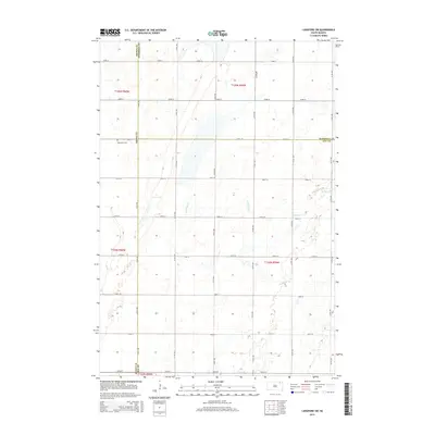
2015 Map of Langford SW
USGS Topo · Published 2015About this map
Augustana Cem sits on the western edge of this agricultural landscape, situated near the intersection of 412th Ave and 124th St. This area of South Dakota is defined by a rigorous section-line road grid that segments the prairie into square-mile parcels, reflecting the enduring legacy of the Public Land Survey System. The meandering path of Antelope Cr breaks this geometric regularity as it flows through the central and eastern portions of the quadrangle. The map is a critical record of political geography, capturing the precise junction where Brown Co, Marshall Co, and Day Co meet. This convergence of three counties highlights the rural administrative boundaries that have shaped local history and land ownership in the region since early settlement.
Find a feature on this map
26 named features on this map. Tap any name to fly to it.
Don’t see what you’re looking for? This feature index may not catch every label — zoom into the map to look around manually.
Map Details
Editions of this 2015 Langford SW Map
This is the sole edition of this map. No revisions or reprints were ever made.
Other maps of this area

1895 · Aberdeen
USGS Topo · 1:125,000

1896 · Columbia
USGS Topo · 1:125,000

1952 · Huffton
USGS Topo · 1:24,000

1953 · Milbank
USGS Topo · 1:250,000

1954 · Groton
USGS Topo · 1:24,000

1954 · Aberdeen
USGS Topo · 1:250,000

1956 · Aberdeen
USGS Topo · 1:250,000
1956 · Claremont
USGS Topo · 1:24,000

1958 · Milbank
USGS Topo · 1:250,000

1958 · Spain
USGS Topo · 1:24,000