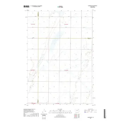
2017 Map of Langford SW
USGS Topo · Published 2017About this map
Augustana Cem sits on a small rise in the northern portion of this landscape, serving as a primary local landmark within a vast network of section-line roads. The terrain is defined by the subtle drainage of Antelope Cr, which winds through the central and eastern sections, creating a series of small wetlands and depressions typical of this part of the Glacial Lake Agassiz region. The area is divided by three county lines, where Brown County, Marshall County, and Day County meet. This survey shows the established agricultural grid in the early 21st century, dominated by thoroughfares such as Co Hwy 16 and Co Rd 11, reflecting a rural economy centered on large-scale land management and the maintenance of township boundaries.
Find a feature on this map
26 named features on this map. Tap any name to fly to it.
Don’t see what you’re looking for? This feature index may not catch every label — zoom into the map to look around manually.
Map Details
Editions of this 2017 Langford SW Map
This is the sole edition of this map. No revisions or reprints were ever made.
Other maps of this area

1895 · Aberdeen
USGS Topo · 1:125,000

1896 · Columbia
USGS Topo · 1:125,000

1952 · Huffton
USGS Topo · 1:24,000

1953 · Milbank
USGS Topo · 1:250,000

1954 · Groton
USGS Topo · 1:24,000

1954 · Aberdeen
USGS Topo · 1:250,000

1956 · Aberdeen
USGS Topo · 1:250,000
1956 · Claremont
USGS Topo · 1:24,000

1958 · Milbank
USGS Topo · 1:250,000

1958 · Spain
USGS Topo · 1:24,000