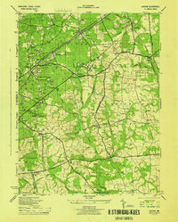
1944 Map of Lanham
USGS Topo · Published 1944About this map
Pennsylvania Railroad tracks and the Defense Highway bisect the rolling landscape of central Prince George's County during the final years of the Second World War. This mid-century view shows a rural and institutional landscape on the verge of suburban expansion, dominated by large facilities such as the Beltsville Research Center and the Bureau of Standards. A network of small schools like the Old Lanham Sch and McCarthy Sch serve localized settlements, while larger institutions like the Glenn Dale Sanitorium and Divine Savior Seminary occupy significant acreage.
Find a feature on this map
68 named features on this map. Tap any name to fly to it.
Don’t see what you’re looking for? This feature index may not catch every label — zoom into the map to look around manually.
Map Details
Editions of this 1944 Lanham Map
This is the sole edition of this map. No revisions or reprints were ever made.
Other maps of this area

1892 · Laurel
USGS Topo · 1:62,500

1892 · Owensville
USGS Topo · 1:62,500

1894 · Laurel
USGS Topo · 1:62,500

1894 · Relay
USGS Topo · 1:62,500

1895 · Owensville
USGS Topo · 1:62,500

1897 · Laurel
USGS Topo · 1:62,500

1899 · Patuxent
USGS Topo · 1:125,000

1900 · Washington
USGS Topo · 1:62,500

1905 · Owensville
USGS Topo · 1:62,500

1906 · Patuxent
USGS Topo · 1:125,000