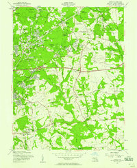
1957 Map of Lanham
USGS Topo · Published 1958About this map
Greenbelt and the sprawling U S Department of Agriculture Research Center anchor the northwestern corner of this mid-century Maryland landscape. The area is defined by a transitional mix of established agricultural research grounds and rapidly expanding residential settlements like Carrollton, Seabrook, and Lanham. The Pennsylvania Railroad cuts a diagonal path through the terrain, serving the station at Glenn Dale, while the emerging automotive era is visible in the construction of the John Hanson Highway. Notable landmarks such as the Glenn Dale Sanatorium and the Radio Station (WWV) illustrate the significant institutional and federal footprint in Prince George's County during this era. Further south, the landscape softens into drainage basins like Western Branch, where smaller communities such as Largo and Beane remain more sparsely settled amidst the winding country roads.
Find a feature on this map
76 named features on this map. Tap any name to fly to it.
Don’t see what you’re looking for? This feature index may not catch every label — zoom into the map to look around manually.
Map Details
Editions of this 1957 Lanham Map
2 editions found
Other maps of this area

1892 · Laurel
USGS Topo · 1:62,500

1892 · Owensville
USGS Topo · 1:62,500

1894 · Laurel
USGS Topo · 1:62,500

1894 · Relay
USGS Topo · 1:62,500

1895 · Owensville
USGS Topo · 1:62,500

1897 · Laurel
USGS Topo · 1:62,500

1899 · Patuxent
USGS Topo · 1:125,000

1900 · Washington
USGS Topo · 1:62,500

1905 · Owensville
USGS Topo · 1:62,500

1906 · Patuxent
USGS Topo · 1:125,000