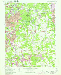
1965 Map of Lanham
USGS Topo · Published 1979About this map
The Goddard Space Flight Center (NASA) dominates the northern landscape of this Prince George's County survey, reflecting the rapid transformation of the Maryland suburbs during the space-age expansion of the mid-20th century. While institutions like the Glenn Dale Hospital and the Marietta Manor Historic Site anchor the area's social and historical identity, the map also captures the encroaching urbanization of communities like Lanham, Seabrook, and Bowie. The network of the Conrail railroad and the Capital Beltway underscores the region's importance as a transportation corridor between Washington and Baltimore.
Find a feature on this map
143 named features on this map. Tap any name to fly to it.
Don’t see what you’re looking for? This feature index may not catch every label — zoom into the map to look around manually.
Map Details
Editions of this 1965 Lanham Map
4 editions found
Other maps of this area

1892 · Laurel
USGS Topo · 1:62,500

1892 · Owensville
USGS Topo · 1:62,500

1894 · Laurel
USGS Topo · 1:62,500

1894 · Relay
USGS Topo · 1:62,500

1895 · Owensville
USGS Topo · 1:62,500

1897 · Laurel
USGS Topo · 1:62,500

1899 · Patuxent
USGS Topo · 1:125,000

1900 · Washington
USGS Topo · 1:62,500

1905 · Owensville
USGS Topo · 1:62,500

1906 · Patuxent
USGS Topo · 1:125,000