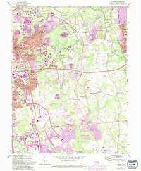
1965 Map of Lanham
USGS Topo · Published 1993About this map
The Goddard Space Flight Center (NASA) and the Nasa campus dominate the northwestern corner of this Prince George's County survey, illustrating the significant federal presence in the area. Surrounding this technological hub are established communities like Lanham, Seabrook, and Greenbelt, which are shown undergoing substantial post-war suburban expansion. The 1993 purple revision tinting highlights the rapid filling-in of residential developments between older landmarks such as the Glenn Dale Hospital and the Marietta Manor Historic Site.
Find a feature on this map
95 named features on this map. Tap any name to fly to it.
Don’t see what you’re looking for? This feature index may not catch every label — zoom into the map to look around manually.
Map Details
Editions of this 1965 Lanham Map
4 editions found
Other maps of this area

1892 · Laurel
USGS Topo · 1:62,500

1892 · Owensville
USGS Topo · 1:62,500

1894 · Laurel
USGS Topo · 1:62,500

1894 · Relay
USGS Topo · 1:62,500

1895 · Owensville
USGS Topo · 1:62,500

1897 · Laurel
USGS Topo · 1:62,500

1899 · Patuxent
USGS Topo · 1:125,000

1900 · Washington
USGS Topo · 1:62,500

1905 · Owensville
USGS Topo · 1:62,500

1906 · Patuxent
USGS Topo · 1:125,000