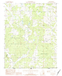
1983 Map of Lanton
USGS Topo · Published 1984About this map
Lanton and Cornertown anchor this survey of the Missouri-Arkansas border region in Howell County, where the landscape is defined by the high crest of Myatt Dividing Ridge. The map illustrates a complex network of drainage basins, with the South Fork Spring River and numerous hollows like Devils Den Hollow and Sycamore Hollow carving through the Ozark terrain. A significant portion of the southern area is occupied by the White River State Forest, while the presence of a Lime Klin and family-named landmarks like Meitaberger Cem provide glimpses into the local industry and settlement patterns of the early 1980s. Water features are particularly dense in the northern section, including Tingler Lake, Slace-Shannon Lake, and Myatt Pond.
Find a feature on this map
37 named features on this map. Tap any name to fly to it.
Don’t see what you’re looking for? This feature index may not catch every label — zoom into the map to look around manually.
Map Details
Editions of this 1983 Lanton Map
This is the sole edition of this map. No revisions or reprints were ever made.
Other maps of this area

1938 · West Plains
USGS Topo · 1:24,000

1940 · West Plains
USGS Topo · 1:24,000

1943 · Thayer
USGS Topo · 1:62,500

1944 · West Plains
USGS Topo · 1:62,500

1946 · Thayer
USGS Topo · 1:62,500

1946 · West Plains
USGS Topo · 1:62,500

1950 · Salem
USGS Topo · 1:62,500

1951 · Salem
USGS Topo · 1:62,500

1957 · Poplar Bluff
USGS Topo · 1:250,000

1959 · Poplar Bluff
USGS Topo · 1:250,000